Monthly Archives: January 2018
Rediscovered/Restored: St Peter’s Wells, Peterchurch, Herefordshire
“The stone head from the mouth of which the main spring flows, pictured in Mrs Leather’s the Folklore of Herefordshire has miraculously survived the tanking of this well for a water supply, although he is now buried almost up to his nose in concrete.”
Jonathan Sant 1994’s Healing wells of Herefordshire
Such was the description that when I was touring the area visiting holy and healing wells in Herefordshire I gave St Peter’s Wells a miss thinking I’d be disappointed. However, the well was a notable one John Littlebury in his 1876, Directory and Gazetteer of Herefordshire notes that:
“The water of these wells was formerly extensively used for the cure of rheumatism and sore eyes.”
Indeed these appear to other springs, and this explains the name, St Peter’s Wells, Ella Leather in her Folklore of Herefordshire notes of these:
“There were formerly three springs here. Two near together, above the large well, were good for eye troubles; into these pins were thrown. They are now closed up.”
Ella Leather continues:
“The water of the larger well flowed through a sculptured head of St Peter into a shallow bathing place made for the use of sufferers from rheumatism. Mr J. Powell, of Peterchurch, told me in 1905, that he could remember this chilly remedy being actually used: it was in his boyhood. The ash tree which formerly stood near the well had been cut down, and still lay above it.”

It is evident from Leather’s photo that the head no longer had a flow of water through it and it appears that the bath was no longer beneath it. I would suggest that the head had not flowed for some time because it is clean and lacking in any moss which would come with constant water. L. Richards in his 1935 Wells and Springs of Herefordshire notes that:
“A considerable quantity of water issues from sandstone in the neighbourhood of St. Peter’s Wells above Wellbrook Farm and gives rise to Well Brook—joined by a tributary from a good spring in Bradley’s Wood—which flows under the road at Crossway and so into the River Dore. The spring water is hard, especially that from the ‘ Limestone ‘ which is well displayed in a quarry below Urishay Castle and on analysis by C. C. Duncan, F.I.C., F.C.S., proved to be 96.37 per cent, carbonate of lime.”
This hard water may explain its use for rheumatics perhaps.
Ancient pagan well?
With such a prominent head it is not surprisingly that there has been conjecture over a pagan origin, citing the Celtics fascination with heads, especially in connection with wells It is interesting that an ash tree is mentioned Ash trees were thought be sacred in pagan times and where associated with the legend of Odin’s eye and the well, but of course it is a common tree and it could be a coincidence. Sant (1994) notes:
“An iron cross has been found in the wood above the well, and this may have come from the well where it would have lent a less pagan air to the place.”
Where there was a link is not clear considering it was found in the woods and not at the well
A bath and baptism
Sant (1994) notes that the baths were provided with a:
“ shed for the rheumatic bather’s use.”
And according to George Marshall in 1933–5, ‘Fourth field meeting, 1933’, Tr. of the Woolhope Naturalists’ Field Club 1933–5: xxvi–ix states that:
“up to quite recent times, baptisms were performed here, the bath being approached by eight stone steps. Mr Watkins explained that the steps and bath into which they lead was choked to the top with earth and the head was covered with water until recently, when excavations were made and the well renovated.”
Adopted for a water supply
The bath was restored in 1932 according to Richardson 1935 but this was short lived for it was soon adopted as a local water supply for the town
“Village Supply.—This belongs to the ‘ Peterchurch Water Supply Company ‘—a company constituted by an Indenture dated 2nd February, 1921,and consisting of the users of the scheme. There are two separate undertakings: a spring from sandstone collected at outburst into a brick tank above Wellbrook (by the side of the road to Stockley Hill where it is joined by the lane from St Peter’s Wells supplies the lower part of the village….”
The current reservoir was installed here in the 1960s, and its insensitive positioning rendered the ancient stone head redundant as noted by Sant 1994 and shown below.

St Peter’s Well head taken by Jonathan Sant c1994 copyright Sant
The restoration
However in 2015, as part of an infrastructure upgrade, a way was found to direct excess water through the stone head and water once again flowed through its mouth. In periods of very low groundwater levels the flow from the stone head may be reduced to a trickle due to demands from the water supply network.
When I did finally visit the site in 2017 I was delighted indeed to see this head restored to its usage and the well chamber visible, albeit difficult to approach as a result of the fence which understandable is around the site to protect the water supply. It now boasts to be the most notable holy well in the county once again.
Boundary spring or Holy Well? Brettenham’s St. Chad’s Well
Back in the mid 90s when I started seeking out holy wells, I came across reference to a site just outside of Thetford. I’d planed to visit the site and found it to be one of the most curious in the county. It is marked on the first series of the OS map in Gothic writing but was it that old?
A substantial site is located in Shadwell Park called St. Chad’s Well (TL 933 830). However, despite the name I can find no history or traditions about it, the first author to refer to the well is Bryant (1901) who states it is marked on an ancient map but as I note below I have been unable to substantiate this. Was it an ancient well?
Icewell, holy well or folly?
The well is enclosed is a circular dome of flint and mortar with a passage entrance facing west. The structure is supported by a stone pillar. The structure is not dissimilar to an ice-well which indeed it has been claimed it was but no-one would build an ice-well with a spring in it. A medieval fabric claim was made, but is of probable 19th Century date and is an estate folly; a grottification of a simple spring, utilising old stone work. This spring arises from the hillside and enters into a basin kerbed in stone through a hole in the flint wall of the structure. Above this is an arched recess. The water is channelled into a narrow gutter to exit through the north wall. The concrete floor of the chamber is below ground level reached by five stairs in the passageway. There are two lighting niches in the walls at the east and the southwest. Six stone blocks are arranged to form seats. Below the arch of the spring of the arch of the domed roof are six brackets which possibly served as candle stands.

St Chad or Boundary spring?
Unlikely although St Cedd his brother evangelised East Anglia, Chad wells are very common in the region. This is because they arise from the Old English Chaud meaning cold and thus cold spring! In this case it is apparent that the name may well be a back-derivation as its location on East Hall and Gonville Manors boundary suggests name derives from O.E scead for ‘boundary’ this is emphasised by the name of the estate Shadwell – sceadwell! Indeed the estate Shadwell Court is only first mentioned in White (1845) as the house was built in the 1830s with associated statues. Historic England records:
“Robert Buxton acquired the manor of Rushworth in Shadwell during the C16, initially holding a lease from the fourth Duke of Norfolk. In c 1715 John Buxton, amateur architect of Channonz Hall in Tibenham, began to rebuild what he called Shadwell Lodge and to lay out the grounds. The main features however of the design which survives today (1999), including the layout of the plantations and the creation of the lake, are the work of his son, also John, between the 1740s and 1760s and these are recorded on William Faden’s map of the county dated 1797. “
This suggests the well was a folly capitalising on the spring name using the carved stonework which may have originally been part of Thetford Priory, giving it a rustic religious feel. However this does not mean that the well was not of significance. Boundaries often incorporated springs as sites of note, or as disputed sites and having them on boundaries allowed equal access. As many Parish boundaries date from Angl0-Saxon periods it is possible that the well had a significant position in the settlement. There is evidence of an ancient settlement here with flint flakes and blades from the Neolithic and Bronze Age were found around the well and Roman funeral urns and Saxon tumuli in the park. Furthermore the well is also located close to Peddar’s Way, suggesting pilgrim use perhaps. So was it a Holy well as noted 1870-72, John Marius Wilson’s Imperial Gazetteer of England and Wales:
“SHADWELL……It takes its name from a spring called St. Chad’s well, formerly much frequented by pilgrims.”
This begs the question is this just antiquarian fancy or are we missing some records of its history? Was it frequented by those on the way to Walsingham…if so its forgotten by them now.

A Staffordshire field trip the sulphur springs of Codsall
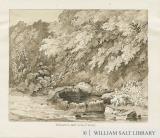
As part of my research for the forthcoming Holy wells and healings springs of Staffordshire I sought out the existence of two sulphurous wells in the Parish of Codsall. The first of these was called the Brimstone Well a wonderfully evocatively named site. However despite some early sketches it appears to be largely forgotten. One illustration shows a circular rough stone well head among leafy foliage in the William Salt Collection. An account locates it as:
“Halfway up the road between Wheatstone Park and Pendrell Hall is a sulphur spring – the medical properties of the water being noted in Plot’s ‘Natural History of Staffordshire’ (1898)…Sometimes the water oozes through the tarmac surface of the road.”
There did not appear to be any well head matching the description between the two locations, although there was a rush lined pool close by. Enquires made in the hamlet of Codsall Wood failed to locate the site and apparently it has been lost. I traversed the area for some time up and down the lanes and concluded that.

The other is more famed, being the Leper’s Well by comparison it was easy to locate, especially as I had the company of Kate Gomez author of the excellent Little Book of Staffordshire and Lichfield Lore blog. This was another site according to Plot (1696) which is:
“sated with sulphurous particles; for it always emits a sulphurous smell: and in winter, and sometimes against rain, the odour is so strong, that, with the advantage of the wind, one may smell it now and then at least 23 yards off. Moreover, so volatile is it, and so little restrained, that when set over the fire, it flies away so fast, that the water quickly loses its smell.”
Plot (1696) continues:
“In ancient times, when leprosies were frequent, this water was accounted a sovereign remedy for such as were troubled with that foul distemper; and for whose better accommodation there was a house built near it, which retains to this day the name of the Leper House. This water is in use at present against scabs and itch, both in man and beast, and purges both by ‘siege and urine. It not only rakes the body within, but most effectually drives forth all ill humours, and sometimes it vomits, according to the constitutions of the patients, who commonly drink about three quarts at a time. Less, scarce works except by vomit, where it meets with weak stomachs.”

This Leper House now a small farm still exists a few yards above the well on the other side of the road. Plot also notes continues to note that the inhabitants hereabout brew their drink with this water, especially at that which they call the Brimstone Alehouse; and boil their meat with it. Upon which it is observed, that none of them are ever troubled either with scabs or itch, or such like cuticular diseases.
William Pitt in his 1817 A Topographical History of Staffordshire notes that the spring arose, up through the hollow stump of a tree, and runs down the road, leaving a yellowness on the moss resembling flour of brimstone: in warm dry weather it emits a sulphurous exhalation. However, this is clearly not the Leper well but if the sketch in the Salt collection is to be believed the Sulphur well. It was also noted that well dressing seems to have been customary in the area, however which wells and when is unclear not when it ceased. The well is a keyhole shaped stone lined well now enclosed by a fence for safety reasons. A large ash tree found over the well in the 1990s appears to have been felled probably because its roots were damaging the fabric or generally unsafe. The water is covered with thick duckweed but when disturbed there is a clear smell of sulphur. Around four steps can be traced on the east side of the well and it is probably considering the size that the well was designed for bodily immersion. This would of course link with the idea of its use by lepers. The only disadvantage is the barbed wire. I jumped over for a closer look and tore my trousers but that was preferable to being as pixy led as I was finding the Brimstone well.
