Category Archives: London
Lost holy and healing wells of London: The wells of Westminster.
Perhaps the earliest holy well recorded in the city, is that associated with a vision of St. Peter by fisherman on Thorney Island before Westminster Abbey was built, is told by Sulcard of Westminster in around 1076 in his The Building of Westminster translated by J. Flete’s 1909 The History of Westminster Abbey. Dating from the days of Abbott Mellitus the founder of Westminster, a bright light was seen by that fisherman on a Sunday night on the opposite Lambeth shore. The ferry then carried across a vision of St Peter who consecrating the new church and as he stepped off onto the shore he is said to have:
“thrusting his staff into the ground behind him he made a flowing spring; then, after he had walked on a little, he thrust in the staff and created another one; and these two springs continued to flow for many years, until at last they were washed away by the river.”
The site was called St. Peter’s Well, and although Sulcard suggests that it was lost two sites surprisingly, were identified by Stanley (1868) as the site a well in St. Margaret’s Churchyard and a pump, in the green of Dean’s Yard. Both are now lost.
A conduit head above St James’ Palace called James Head in 1598 may recall a St. 20 James’s Well, although there is no firm evidence. However, more convincing is St Clement’s Well which is mentioned J Stow’s 1598 Survey of London states that
“the fountain called St Clement’s well, north from the parish church of St Clement’s and near unto an inn of Chancerie called Clement’s Inn, is fair curbed square with hard stone, kept clean for common use, and is always full.”
W. Maitland in 1756’s The History and Survey of London notes that:
“the Well is now overed, and a Pump plac’d therein, on the East Side of Clement’s-Inn, and lower End of St Clement’s-Lane.”
A.S Foord’s 1910 Springs, Streams, and Spas of London reports that:
“the holy well of St Clement… has been filled in and covered over with earth and rubble, in order to form part of the foundation of the Law Courts.”
This appears to be the first specific reference to the change from a draw-well to a pump. D. Hughson (1806-09) London British Metropolis, and T. Allen (1827-29) The History and Antiquities of London both allude briefly to the well, but Sanders (1842):
“The well is now covered with a pump, but there still remains the spring, flowing as steadily and freshly as ever.”
G. R. Emerson’s 1862 London how the great city grew, when discussing the Church states:
“It stood near a celebrated well, which for centuries was a favourite resort for Londoners. The water was slightly medicinal, and having effected some cures, the name Holy Well was applied.”
J. Diprose’s 1868 Some account of the Parish of St Clement Danes Past and Present, a local inhabitant states:
“It has been suggested that the Holy Well was situated on the side of the Churchyard of St. Clement), facing Temple Bar, for here may be seen a stone-built house, looking like a burial vault above ground, which an inscription informs us was erected in 1839, to prevent people using a pump that the inhabitants had put up in 1807 over a remarkable well, which is 191 feet deep, with 150 feet of water in it. Perhaps this may be the ‘holy well’ of bygone days, that gave the name to a street adjoining.”
J. Timbs’ 1853 The Romance of London: strange stories, scenes and remarkable persons of the Great Town states that:
“the holy well is stated to be that under the Old Dog’s tavern. No. 24, Holywell Street.”
Foord (1910) states that other inhabitants believe that the ancient well was adjacent to Lyon’s Inn, which faced Newcastle Street, between Wych Street and Holywell Street Foord (1910) also notes that in the Times of May 1st 1874, reads:
“Another relic of Old London has lately passed away; the holy well of St. Clement, on the north of St. Clement Danes Church, has been filled in and covered over with earth and rubble, in order to form part of the foundation of the Law Courts of the future.”
He also notes that The Standard of the 3rd of September 1874 the site is states that report of the Times was erroneous and that the well was still ‘delivering into the main drainage of London something like 30,000 gallons of water daily of exquisite purity’ and that it would be utilised for the new Law Courts. Interestingly, a contributor to Notes and Queries (9th series, July 29, 1899) draws attention to the following particulars from a correspondent, a Mr. J. C. Asten, in the Morning Herald of July 5, 1899:
“Having lived at No. 273, Strand, for thirty years from 1858, it may interest your readers to know that at the back of No. 274, between that house and Holy Well Street, there exists an old well, which most probably is the ‘Holy Well.’ It is now built over. I and others have frequently drunk the exceedingly cool, bright water. There was an abundance of it, for in the later years a steam-printer used it to fill his boilers.”
Foord (1910) states that:
“In order, if possible, to obtain some corroboration of the Standards statement that the spring existed in 1874, the writer applied for information on the point to the Clerk of Works 2 at the Royal Courts of Justice, who wrote that he could find no trace of St. Clement’s Well, so that the report in the Times (quoted above) is probably correct. The water-supply to the Courts of Justice, he adds in his letter of June 13, 1907, is from the Water Board’s mains… On the Ordnance Survey Map, published in 1874, a spot is marked on the open space west of the Law Courts with the words ‘Site of St. Clement’s Well’ this spot is distant about 200 feet north from the Church of St. Clement Danes, and about 90 feet east of Clement’s Inn Hall, which was then standing. The Inn, with the ground attached to it, was disposed of not long after 1884, when the Society of Clement’s Inn had been disestablished.”
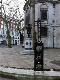
On the edge of the pavement in a metal plaque which records the digging of a well and perhaps this is the improved site of St Clement’s well.
A Sylvanus Urban’s 1852 ‘Antiquarian researches’, Gentleman’s Magazine 2nd ser states that a draw-well beneath the Old Dog Inn was a Holy Well and gave its name to the now lost Holywell Street. However, J. Gover, H. Mawer and M. Stenton’s 1943 Place-names of Middlesex states that the name derives from O.E hol, from ‘hollow’.
Severed Heads and Sacred Waters – Anne Ross (illus. R.W. Feachem) Source Issue 5 Spring 1998 part two
The River Thames gets its name from the Celtic Tamesis, “the Dark One”, probably the name of a goddess, because rivers seem to have largely been thought of as being feminine by the Celts. This is interesting because Adamnan, biographer of Saint Columba, mentions a river in Scotland called, in Latin, Nigra Dea, “Black Goddess” (Watson 1926, 50). Thus, here the river is the goddess, and so, we may suppose, was the Thames. There is, in fact, a whole series of “black goddess” rivers in the Scottish Highlands. The Nigra Dea of Lochaber is the modem River Lochaidh. So the name of the Thames itself points to an early belief in its dark powers which led, no doubt, to propitiatory sacrifice. It may not be irrelevant here to mention the fact that the ancient Irish goddess Macha, whose form was often that of a crow or a raven, had human heads offered up to her as her due, usually heads taken in battle. These were known as Mesrad Machae, “Macha’s Mast”.
We began by looking at heads and boundaries and this theme recurs when we consider the heads taken from Thames and Walbrook. The Walbrook, “Brook of the Welsh”, a former tributary of the Thames, shared with the larger river an amazing offering of human heads. Moreover, the Walbrook was a boundary river. Many human skulls, most of Iron-Age date, were found in the Walbrook, some forty-eight of which are recorded. They showed no sign of injury and, predictably, they were usually the skulls of men in the prime of their lives, under forty years of age. Human skulls were constantly found when the River Thames was dredged in the nineteenth century, often together with important finds of metalwork, mostly weapons, some of stunning workmanship. One location near Battersea Bridge, famous for its finds of Celtic metalwork, was actually known as a Celtic Golgotha in the nineteenth century (Cuming 1857, 238). Because of the fine quality and richness of the metalwork the extraordinary number of human heads tended to be disregarded. Cuming wrote a paper entitled “On the Discovery of Celtic Crania in the Vicinity of London” -a fine title – but a year later his attention was diverted to the stunning Battersea shield, and he seems to have lost interest in the skulls.
A large number of skulls was then found in the river at Strand-on-the-Green, but this hardly received mention. People virtually forgot about the skulls. Then it came to be realised that the great quantities of metalwork in rivers and lakes in Britain and Europe must be there due to ritual and offering, rather than being casual losses, which is how they were usually described: but no mention seems really to have been made of the human remains that were often found with them. It seems that the discovery of Lindow Man, and the female head found in the same level of the Moss, touched off a new interest in the London skulls. Could these, after all, owe their prolific presence in the waters to ritual, it was asked. In the same light we must consider the skulls at Wookey Hole (Ross 1992, 142-3), and other such finds in watery places.
Forty-eight skulls have been recovered from the Walbrook, and others from Kew and Hammersmith. It is extremely fortunate that about 300 skulls taken from the Thames still survive today in museum collections; and this enquiry has set in motion a new interest in skull collections generally, and in the find-spots. A great many of the Thames skulls were found between Richmond and Mortlake. The same area has yielded major finds of Bronze Age and Iron Age metalwork. Some of the skulls are dated to the late Bronze Age, which demonstrates a convincing continuity of ritual and practice of the cult of the head in connection with watery places. Of particular significance is the fact that rarely if ever were the skulls found together with other human remains. The skull itself, then, is the part that was offered. The continuity of this practice did not end with the coming of the Roman period: there are a few skulls dated to the post-Roman, Saxon, era.
Noteworthy are the ten human skulls and six mandibles which were found in the River Lea, a tributary of the Thames. It is interesting to note that Ekwall suggests, on etymological grounds, that Lea is likely to mean “the river of the god Lugus”. The Lea, then, flows into the “Dark One”, and surely some ancient and profound cult is indicated. Is it by chance, I wonder, that Bran’s head was brought to Londinium as a talisman, and buried in a place where many springs flow, as an apotropaic emblem, in order to keep all invaders away from Ynys Prydein, “The Island of Britain”? It is to Ireland we must turn now for some further dramatic evidence for the cult of the head, as attested by archaeology. The excavation of a destroyed late Iron Age burial at Kiltullagh, Ballyglass, Co. Mayo, has yielded further evidence of the cult of the human head (Cribbin et. al. Emania 1 f.). On the borders of Mayo and Roscommon a quarry opened up in 1991 destroyed important evidence but incidentally revealed some interesting features.

The margins of the quarry remained undisturbed, and there were indications that there had been a large mound before operations had begun. The date is in the late Iron Age, and a large stone that was present would seem perhaps to have served as a boundary market An almost identical mound lies undisturbed on the Roscommon side of the county boundary, and excavation of this may cast light on what remains of the destroyed Mayo site. The place was used for burials of some kind, but its particular interest for us here is that it would seem once again to cast light on Iron Age cult practice with regard to the human head. About seventy fragments of human bone were examined, but the singular feature is that they were for the most part skull bones and mandible fragments. The bones were fragmented and had dearly been damaged by the quarrying. Fragments of skulls both male and female were present, seeming to belong to some four people. The fragment of the mandible of a young child, aged about three to five years, was recovered more recently. There is no evidence that the burials were contained in any form of cist, or that they were articulated. Most interesting to us are the skull fragments. It is unlikely that conventional burial was carried out at this site, the amount of bone other than skulls and mandibles being far less than would be expected with a normal burial of up to five people. Some kind of ritual deposit associated with the head cult is indicated. It is now apposite to consider a closely similar skull burial found recently at Raffin, Co. Meath (Raftery 1994, 80). Here an internal bank surrounds circular houses of both Bronze Age and Iron Age date, itself an interesting point. Here also was a standing stone at the base of which were buried a human skull and some animal bones. The skull fragment produced a date of 100 B.C. to A.D. 30. The Bronze Age houses would certainly favour an earlier date for some at least of the site; but Irish sites tended to have a long continuity where ritual activity or superstitious regard kept their significance alive. The Kiltullagh bones included those of pig, cattle, and others. These skull burials beneath standing stones bring to mind such parallels in Gaul in the Roman period as, for example, an altar dedicated to the Celtic Mars at Apta Julia – Apt, Vaucluse. This was found to have a duster of some eight skulls buried beneath it (Ross 1992, 99). The skull at kaffin would seem to have been that of an adult male. Raftery describes the site as an Iron Age hilltop of suggested ritual character (Raftery 1994, 80). There may perhaps have been a monument here comparable in function to the great royal centres. The skull was actually in a pit, the position of which was marked by a squat, naturally-rounded boulder. Emain Macha – Navan Fort – situated on a hilltop near Armagh, is perhaps the most important ritual site in Europe (•ynn 1991, 41 f). The head of a Barbary ape discovered there may perhaps indicate both the worship of the head and the special place accorded to an exotic species. Its presence has led to much speculation about how and why it came to be there. The name of a lough at the foot of the hill – Loughnashade – means, I think, “Lough of the Treasures”. And treasures it did indeed contain. Many have been recovered from it in the past: four magnificent sheet-bronze trumpets have been preserved from a dredging of 1798; it is not in question that these were ritually deposited. The recovery of human skulls also from the lough makes parallels with the Thames and other British rivers, and their caches of skulls and metelwork, very dose indeed. Gregory of Tours, in the sixth century, mentions a lakeside festival in Gaul during which votive offerings were thrown into the lake.

We are not told whether these included human skulls.
Another very unusual ritual site forms part of this fascinating Navan complex. It is known as the King’s Stables, and consists of an artificial pool sunk deep into the ground. The evidence shows that this had been constructed for ritual purposes between 1200 and 600 B.C. A layer of charcoal was discovered when a hole was dug during a fencing operation in 1987. The monument survives in reasonably good condition for a small site, and for one of such a great age. Many large prehistoric monuments in the district have been entirely destroyed, and much of value doubtless lost for all time. The artificial pool has a fearsome guardian in the form of a dragon-like creature, and fear of this guardian may have served to preserve the site. There is a tradition that a passage leads from Loughnashade to the King’s Stables. The artificial pond is always full of water, and folk tradition has it that the kings of Ulster “loing ago” used to water their horses there, and wash their chariots. One day a local character decided to drain away the water. He began to cut at the bank and “to destroy its fine round shape”. He had hardly started, however, when the monster appeared, and you could hardly see the water because of its great size. He was never the same again, and was confined to bed for some time after this encounter (Emania 2, 20). Of great interest in this context is the deliberate deposition in the King’s Stables pool of part of a human skull. The skull, seemingly that of a young male adult, showed signs of cutting after the individual had died. It was the facial part of the skull that had been deposited, forming a kind of mask. We may compare this with the skull from Gournay (Lynn 1991, 40).
Similar ritual treatment of skulls is known from other Irish sites. For example, a skull found below the crannog at Lagore, thought to be that of an adult female, lacked the lower mandible, as did a skull found in open water mud to the west of the Late Bronze Age occupation at Moynagh Lough, Co. Meath. The skull of the Barbary ape found at Emain Macha may have been all that was buried there, and may have served as some kind of talisman as did human heads. The Thames skulls and other heads often show a similar ritual treatment. And these skulls, too, were predominantly those of adult males. Skull deposits from Ballinderry raise interesting questions about the use of wet places – which recall Lindow Moss – and it is clear that there is some significant evidence for settlement in such locations in the Late Bronze Age. At the same time there is clearly a continuity of the long-established pattern of using rivers, lakes and bogs, as well as wells and deep shafts, as places for ritual deposits (Lynn, Emania 9, 1991: 40, 41).
These are only some of the seemingly ritual deposits and treatment of heads in the Late Bronze Age and Iron Age as attested by archaeology. I have spent some time in discussing these in order to establish a clear and striking antiquity in Europe for the use of the severed human head in Celtic religion, and therefore in Druidic practice. The theme of the prophetic head is well known, and it is interesting to note that one of the incantations for fore-knowledge used by the Druids and esoteric poets of Ireland was called Dichetal di chennaib, “incantation by means of heads”.
As the classics imply, the setting up of human heads in forts and dwellings secured protection – most probably by inspiring fear in the enemy. Even today, in parts of what was Celtic Brigantia (“The High One”, the eponymous goddess of the region; modern Brigid), heads are regarded as bringing good luck or keeping bad luck at bay. The protective fossilised skull of a young woman at Bettiscombe, Dorset, has been discussed in this issue, and there are others in various parts of the country, accredited with apotropaic powers. Stoner heads are often believed to have a potency similar to that of the real skull, and much superstition still attaches to them.
I have already discussed individual wells associated with a head or heads in publications which are detailed in the bibliography. Space does not permit me to recapitulate them all here. The Highlands and Islands of Scotland are studded with place-names connecting the human head with some well or source, ford or lake, and the same applies to Ireland. Wales, too, as we have seen, has its own share of these; and here, as in the other Celtic countries, the stories and lives of the numerous Celtic saints contain legends concerning the origin of some spring or well through the power of their decapitated heads.
Perhaps the finest well in this country dating from the Roman period, and containing evidence of skull-worship is that at Carrawburgh, in Northumberland (Allason-Jones and Mckay, 1985). Named Coventina’s Well after the presiding goddess – who was also venerated on the Continent – excavation yielded many sacred objects which had been cast into or suspended above the well. From our point of view, the human skull is the most telling. Whether it was first used for purposes of healing, or of prophecy, or of protection -or any or all of these – we shall never know. Its mere presence at the bottom of a hallowed well in a remote part of Roman Britain adds important evidence to the archaic and deeply rooted association of severed heads with sacred waters.
Finally, I want briefly to tell again the story of my own experience of a severed head and a sacred spring, in the Highlands of Scotland. Like so many wells in this wild terrain, the well was known as Tobar a’Chinn, “The Well of the Head”. The skull is famed for its ability to cure epilepsy, of which there was a great deal in the Highlands in the past. The power of the skull could only operate, however, with the potent waters of a mountain spring. The sacred water must be drunk from the human skull, and so the cure was effected. This well and its healing properties were renowned the Highlands, and people came from the Islands as well as the mainland to obtain the cure.
The well is situated on a mountain-side in a wild region of Wester Ross. I visited the township some years ago, and talked with the guardian of the skull and the well – for guardians are an essential and archaic feature of such healing sites. The skull is allegedly that of a suicide, and was found lying on the ground some two hundred years ago, according to the tradition. The “wise men” of the community recognised that it would have powers to heal epilepsy, skulls of suicides allegedly being very potent in this respect. The waters of the spring were already accredited with healing powers, and it was somehow recognised that the well and the skull together would have magical powers; but always to be invoked in the name of the Trinity. The skull was taken up to the well, and was kept in a small stone dst at its side: and there it remains to this day. The guardian, a local healer, was appointed, and the position has remained in the same family to the present day. The well must not be visited for any purpose other than the healing of epileptics: it is the deeply-rooted belief that the powers of the water are not inexhaustible, and must be expended with great care. The skull, too, must only be used in the healing ritual -otherwise it must lie hidden in its stone container. The healing takes place after the last rays of the sun have left the mountain and before first dawn. The climb, and the descent after the ritual has been performed, must be made in silence. I was privileged to visit the well in the dead of night with the guardian, who explained the ritual to me in detail. He told me that after the healing was completed, and the sacred waters had been drunk from the skull, he “put the prohibitions” on the patient. This is a very archaic feature; it occurs in Old Irish in the form of the word geis, (pl. gessi), meaning a tabu, a prohibition, a ritual constraint. Geas is the word still used in Scottish Gaelic, and it is this that the guardian of the well used. It was a rare and awe-inspiring experience, one which seemed to take me right back into the Celtic Iron Age. It gave me a completely new insight into these ancient beliefs and healing rites, all explained in the archaic Gaelic language. I shall always be profoundly grateful to the guardian who so generously instructed me in this sensitive tradition.
Summary and Conclusion The ancient Celtic belief in the powers of the severed human head was widespread and deeply rooted; and it was so firmly embedded in the Celtic subconscious that convincing traces of the ancient veneration accorded to the skull are still extant in the present day. The evidence for the antiquity of this cult is found in archaeological contexts from the Bronze Age onwards, and it can even be traced to the Neolithic in some areas which were to become Celtic at a later period. The head was believed to survive death, and to be capable of speech on occasion, and of movement and poetic utterance (Ross 1992, 94 f). Its powers were those of healing, prophecy and fore-knowledge, fertility and protection, according to traditions down the ages. Skulls were often treated in singular ways as in the case of the Irish skulls, and we are unlikely ever to know the full significance of the small parts of human heads which are often found, clearly deliberately deposited, in archaeological contexts. We briefly considered the important group of temples and sanctuaries in southeast France, dating to centuries immediately before the Roman occupation. Here mediterranean influence is attested by the stone temple buildings and the sculpted representations of gods and heroes in the local limestone, for example. Sophistication here combines with potent evidence both for head-hunting and head-worship, and the connection of heads with sacred springs and waters. Today we can still witness faint but cogent traces of this ancient cult, with its roots in Druidism and Celtic tribal society; and we may say that the symbol of the human head, especially in association with sacred waters, truly epitomises Celtic religion. When paganism officially gave way to Christianity, there was a natural fusion of god head and the Godhead. The head of the Welsh Bran the Blessed perhaps symbolises this most poignantly (Jones and Jones, 1977, 49), a head buried in Londinium where the cult of the Iron Age Celts is attested by a dramatic assemblage of human skulls deposited in the sacred waters of the River Thames and its tributaries. Future dredging of rivers, and excavations of Iron Age sites, will no doubt bring to light further evidence of these ancient cults, and perhaps add welcome details to what we can reconstruct of ritual and offering, Druidism, and the nature of the gods invoked.
Bibliography
Allason-Jones, L. and McKay, B. 1985. Coventina’s Well. Chesters Museum.
Benoit, Fernand. 1955. L’Art Primitif Mediterraneen de la Vallee du Rhone. Gap: Editions ORPHYR.
Bradley, R. and Gordon, K. 1988. “Human Skulls from the River Thames, their dating and significance”. Antiquity 62: 503-9.
Bromwich, R. 1961, 1978, 1991. Trioedd Ynys Prydein. The Welsh Triads. Cardiff: University of Wales Press. (New edition in preparation.)
Brunaux, J.L. 1988. The Celtic Gauls: Gods, Rites, Sanctuaries. London: Seaby.
Cooney, G. and Grogan, E. 1991. “An Archaeological Solution to the ‘Irish’ Problem”. Emania 9: 33-43.11
Cribbin, G., McCormick, F., Robinson, M.E. and Shimwell, D. 1994. “A Destroyed Late Iron Age Burial from Kiltullagh”. Emania 12: 61 f.
Cuming, H.S. 1857. “On the Discovery of Celtic Crania in the Vicinity of London”. Journal of the British Archaeological Association 13: 237-40.
Ekwall, E. 1936. The Concise Oxford Dictionary of English Place-Names. London: Oxford University Press.
Hickey, H. 1976. Images of Stone. Belfast: Blackstaff.
Jones, G. and Jones, T. 1977. The Mabinogion. London: Dent.
Koch, J.T. and Carey, J. 1994. The Celtic Heroic Age. Massachussetts: Von Kamecke.
Megaw, R. and Megaw, V. 1989. Celtic Art London: Thames and Hudson.
Lynn, C.J. 1991. “A Burnt Layer beside the King’s Stables”. Emania 9: 33-43.
O’Rahilly, C. (ed.). 1976. Tain Bo Cuailnge (Recension 1). Dublin. Piggott, S. 1968. The Druids London: Thames and Hudson.
Raftery, B. 1994. Pagan Celtic Ireland. London: Thames and Hudson.
Ross, Anne. 1962. “Severed Heads in Wells: an Aspect of the Well Cult”. Scottish Studies 6, part 1: 31-48.
– 1967, 1972. Pagan Celtic Britain. London: Routledge. London: Constable. – 1976. The Folklore of the Scottish Highlands. Batsford.
Rybova, A. and Soudsky, B. 1962. Libenice. Prague. Salviot, E 1979. Glanum Paris. Stead, I, Bourke J, and Brothwell, D, 1986. Lindow Man, The Body in the Bog. London: British Museum Publications.
Tierney, J. J. 1960. “The Celtic Ethnography of Posidoneus.” Proceedings of the Royal Irish Academy 60, c.
Watson, W.J. 1926. The History of the Celtic Place-Names of Scotland. Edinburgh and London: Blackwood.
See also: Emania 2 (1987), for articles on Emain Macha and Loughnashade.
Will the real Mossy Well of Muswell hill reveal itself?
Many years ago a friend of mine claimed his mother had discovered the location of the Muswell and she had become a bit of an expert on it. I remember her claiming that it was in a cupboard which at the time I thought was odd although I did not challenge her and forgot about it until now. In truth there still appears to be some confusion over the titular well of this well-known, London area- Muswell The name of this well has been confused, the most obvious is the secular Mossy well, which has been interpreted as Moses Well or St. Mary’s Well. Harte in his 2008 English holy wells suggests that the site is synonymous with St. Mary’s Well at Willesden. However, John Norden’s Speculum Britanniae of 1593. He wrote:
‘at Muswell Hill, called also Pinnersnall Hill, there was a chapel sometime bearing the name of Our Lady of Muswell where now Alderman Rowe hath erected a proper house. The place taketh the name of the well and the hill, Muswell Hill, for there is on the hill a spring of fair water which is within the compass of the house. There was sometime an image of the Lady of Muswell, whereunto was a continual resort in the way of pilgrimage, growing as is fabulously reported in regard of a great cure which was performed by this water upon a certain King of Scots who being strangely diseased was by some divine intelligence advised to take the water of the well in England called Muswell, which after long scrutation and inquisition, this well was found and performed the cure…’
John Aubrey in his Miscellanies, 1696, states that:
‘the water of this well is drunk for some distemper still’.
Indeed it is probable that two wells are under discussion. Stanley Foord’s 1910 Springs, Streams and Spas of London records that:
“in regard of a great cure which was performed by this water, upon a king of Scots, who being strangely diseased, was by some devine intelligence, advised to take the water of a Well in England, called Muswell, which after long scrutation, and inquisition, this Well was found and performed the cure”.
The king believed to Robert the Bruce (the Bruces held land nearby) but Malcolm has also been mentioned, and the illness was thought to be leprosy. Charles Hope in his 1893 Legendary Lore of Holy Wells calls it St Lazarus’ Well, although he is the only source. The author adds that it was ‘situated behind the Alexandra Palace’. Today a private house (no 10 Muswell road) stands on the ‘presumed’ site halfway along the road. Indeed, Muswell road is located just west of Alexandra Park and the famous Alexandra Palace. However there
is also a neglected well in front of a house in Muswell Avenue which has been identified by
one website Earth Stars. Alternatively, another website, https://www.londonslostrivers.com/muswell-stream.html, states emphatically:
“The present day Muswell Road, N10 is the location of the “Mossy Well” where the well still exists but is capped beneath a private house.”
The Hornsey Historical society, https://hornseyhistorical.org.uk/pins-or-muswell-hill/ state:
“The well survived until 1898 and a plaque on No. 40 Muswell Road marks the spot.”
To put a plaque up suggests pretty much certainty and indeed the site does correspond to marks on the first series OS.

The confusion is probably explained as Curls in his 2010 Spas, Wells and pleasure gardens of London notes that there were two holy wells in the area see Tottenham. These were described as being in good preservation at the end of the nineteenth century according to T. K. Cromwell (1823) History and description of the Parish of Clerkenwell. One well was described as producing hard, pellucid and hard water, the other was like rainwater. It is stated that in the mid-1800s, contrary to Cromwell, the landowners of one had sealed one well, prompting a civil action to preserve access for local people. The local people won in the case of 1862 and the Alexander Park Company had to provide a pump. Yet by 1880s the pump had begun to cease to function and the wells were only supplied by surface waters which was polluted. Around this time it was lost, this would appear to be the same site as St Dunstan’s Well. In 2016 workers digging Muswell Hill Broadway revealed a circular 30m deep well, which English Heritage are planning to investigate. Its location is unlikely to be the titular site but it is not impossible
Searching for St Bride’s Well, London
It is not clear whether St. Bride’s Well takes its name from St. Bride’s Church constructed in 11th century. Certainly the name Brydewell is noted in property owned by the Bishop of St David’s in 1487. The Palace of Bridewell was built nearby and thus Stow (1598) notes:
“fell to ruine, insomuch that the verie platform thereof remyned for great part wast, and as it were, but a layestall of filth and rubbish; only a fayre Well remained there… until King Henry the 8 builded a stately and beautiful house thereupon, giving it to name Bridewell’”
The well was outside of the church until the 15th century rebuilding when it was incorporated into the south-east corner of the church. Hone (1826–7), who says:
“the last public use of the water of St Bride’s well drained it… Several men were engaged in filling thousands of bottles, a day or two before the 19th of July 1821, on which day his majesty, King George IV was crowned at Westminster from the cast-iron pump over St Bride’s well, in Bride-Lane.”
I was informed by Mr. Eric Davies informed me that the well ran dry after an enterprising local pub landlord decided to sell water from the well and perhaps this is what Hone above alludes to. The nearby Bridewell Baths were said to have been filled by the spring’s waters explaining perhaps the poor quality of the water. In the crypt museum is a pump tap said to be from the well.
According to Mr. Davies it was the custom to use the water from the well as holy water, to sprinkle on the route of Coronation Processions from the Tower of London to Westminster Abbey, which went along Fleet Street and past the church. Milne (1997) it was ‘still remembered in the early twentieth century as the focus of a formal procession which left the chancel and made its way southwards towards it. A map in the crypt museum notes an unusual feature a south door installed for processions to the well, presumably when the well was at ground level.
After the post-War restoration of the church, the name was assigned to a fountain placed in the northern churchyard, which was removed in 1994. Indeed there appears to be some confusion over what happened to the well and when. Furlong (accessed 2013) states that it disappeared under modern office complexes however the church identify it as being in the crypt and according to Mr. Davies was lost over 100 years ago.
However, according to correspondent the well was still there in the 1970s and was full of water and indeed in the 1990s when a workman was asked whether there was a well there he said there was. However, there is no well to be found at the site in the crypt and indeed the flooring of this chamber appears to be modern. The loss of the well and the adamant statement that the well was there in the 1970s is clearly at odds with the opinion of Mr. Davies who kindly showed me the site. It is possible that the church filled in the well around the 1990s as a response to pagan usage of the crypt and church around St Bride’s Day, in particular the usage of the plane tree said to mark the site of the well and fed off it. The site of the well is shown on maps in the crypt museum be found in the crypt, but not the section which is open to the public.
In the crypt museum the tap from the well which provided a public water supply is shown in one of the museum display cabinets. Outside appears to be an aperture and small trough fed by a pipe which may have been fed from the spring or alternatively from the drains above. One hopes that the mooted but expensive improvements planned to be made to the church will reveal the well once and for all and restore it.
Extracted from Holy Wells and healing springs of London and Middlesex
A lost Essex well – the King’s well of Chigwell
Chigwell on the Essex outskirts of London is a site claimed to have derived its name from a spring called the King’s Well as Samuel Lewis in his 1848 Topography notes:
“within the bounds of the great forest of Waltham and in ancient records is styled Cingwella supposed to imply the King’s Well a purgative spring here from which its present name is derived.”
However did it? According to P. H. Reaney’s Place-Names of Essex the name means ‘Cicca’s well’, Cicca being an Anglo-Saxon personal name. Furthermore, the 18th-century historian Nathaniel Salmon The History and Antiquities of Essex stated that the “-well” element in the name derives from Anglo-Saxon weald meaning wood which would make sense considering its proximity to Hainault Forest. Hence my claim in the book Holy wells and healing springs of Essex that it was
“The King’s well was certainly an ancient site, possibly a pre-Christian origin”
May seem now a little over-enthusiastic!
Philip Morant in his 1763-8 History and Antiquities of Essex gives the earliest account of the well, being found:
“…..behind the wind-mill, among the trees whose water has a purging quality, and the late Dr Frewin used to speak of its flavour….Near the well is a hole wherein the water of the fame nature, perhaps proceeding from the other.”
Morant (1763-8) also suggests that the well was once frequented, but less so by his time. By the end of the 18th century it appears to have become entirely neglected. This situation never improved, as even in 1838, a Professor Booth noted it to be ‘now quite neglected’. This decline lead to its final destruction in the late 1870, when the site was drained, filled in and turfed over, by a Mr. Radley, acting on behalf of the then owner. By the time Christy (1910) visited the site, the well had long gone, but fortunately he too obtained some vital details concerning the well. The well was reached by a private road, although once a public right of way, near a mill pond. Unusually it would appear that the fame of the water differed in regards its appearance, for when yellow it was best only for cattle. He was informed by the older residents of the community that this well laid in a meadow of about thirty acres called ‘Parkfield’, belonging to a Mr. Philip Saville, and near his residence of ‘The Woodlands’. It was situated due south of Forest House, about 300 yards from the road, and not very far from Grange Hill Station. It lay on the steep slope of London clay, lying on the south side of the road.
A description of the site
Fortunately, a description of the site survives. A Mr. Green, who had lived many years in the Parish described the well as a hollow place, bricked around, with steps leading down to the water. Surplus water was relayed to a ditch via pipes. Yet despite its destruction 30 years before, it was still famed in the 1900s. A local man Mr College referred to it as the ‘purging well’. Furthermore a Dr. Reeve, formerly of Chigwell Row, described it as good as any medicine as a purgative.
The site today
In the book Holy Wells and Healing Springs of Essex I recorded that the site was located in Whitehall Close, but there is now nothing to mark it; the area being developed for housing.
Since Morant’s (1763-8) description the whole area has drastically changed. The windmill was burnt down in about the 1850s, and the trees that surrounding the well (part of the old Hanault Forest) were probably cut down even earlier.
However, in 1907 about 50 yards from the reputed site of the well, there was a stagnant cattle pond. Miller Christy and May Thresh’s 1910 A History of the Mineral Waters and Medicinal Springs of the County of Essex believes that this is probably the hollow described by Morant (1763-8). This too has gone.
However, there is some confusion and subsequent research places it more precisely in the rear of the house located at 67 Brocket Way being marked on the land registration map of Redbridge Council shows “Chig Well (site of)”
 However, that might not be the whole story! In an excellent article on the Chigwell Row community blogsite called Chigwell derived from King’s Well or Cicca’s Well the jury is out! the author notes:
“I hope to work on a project to commemorate that early past and have it recognised locally. Hopefully a local project will revive an interest in our historical past like the Mammoth replica project has in Redbridge. I have followed the map I bought with local resident Neil Patel who has lived her for over 40 years. We believe that the location of Chig Well would have been in land adjacent to the wells Park School or at it’s rear. I have contacted the school to try and ascertain whether the name of the school is somehow linked to the history of the well listed on the map. A call to the school office was met with short-shrift and the woman who answered said she knew nothing about the origins and nor would other school staff. she said:“The decision to name the school was made by Essex Council.“They gave the school to options and early decision-makers went with Wells Park School.”When pressed on how Essex Council derived the two name options, I was reminded to contact Essex Council. I have contacted the Essex Record Office who is not able to advise me on the origins of the name of the school, but I will ask the officer there and the school again, in hope of clearing up this mystery. Later it would be able to gain access to the rear of the school or the private land next to it, to locate any remnant of the potential well site.”
It seems sad that such a renowned site, that had given the place its central focus and name, should have been destroyed with little regard for its importance. However one does wonder what they have found in the garden of number 67, or Whitehall Close or as the author above states the School!
An Enfield Field trip
Enfield might not seem the most profitable for holy and healing well hunting but there were some interesting sites. Sadly searching for the first site was less than fruitful. According to Samuel Lewis’s 1831 Topographical directory) there is a spring called King’s Ring, although Hope (1893) calls it Tim Ringer’s Well, he also notes that whose waters never freeze nor dry up. Lewis (1831) notes its location:
“To the south-west of the town, and about a mile from Old Bury, is a smaller moat, on the estate of John Clayton, Esq; and to the south of Goulsdown lane is another, separating two square fields, in the first of which are the remains of out-buildings belonging to a mansion in which Judge Jeffreys is said to have resided, and near the entrance a deep well called King’s Ring, the water of which is deemed efficacious in diseases of the eye: a celt was dug up in 1793, at the depth of twelve feet from the surface.”
G. M. Hodson and E. Ford 1873’s A History of Enfield note that it was on the south side of Nag’s Head Lane, near Ponder’s End. It was a deep well, probably the brick conduit noted in Ogilby’s roads 1698. Mr Leonard Will, local historian notes that Godfrey Maps reproduction of the Ordnance Survey map of Ponders End, 1896, shows King’s Ring (WELL) (Site of) on the south side of Southbury Road, just to the east of Churchbury Station (now called Southbury station).

The site does not appear to have survived as the area is heavily urbanised, it would appear to correspond to Poppy drive and despite some green spaces there nothing could be found!
More mysterious is the pond located in Trent Country Park called Camlet Moat, a name which first appears in 1440 A.D. The name has been thought to suggest that this was the site of the legendary castle of King Arthur Camelot. The site is also noted for a ghost of Geoffrey de Mandeville, Earl of Sussex and Hertfordshire and Constable of the Tower of London whose ghost was apparently first recorded in the 12th century. He is said to guard a pot of treasure he hid down a nearby well before he was arrested for treason. Local legend also records has a paved bottom beneath which the treasure would be found which is protected by a magic spell. Curiously he is also associated with guarding treasure in ‘castle’ well in earthworks at South Mimms (cf Holy Wells and Healing Springs of Hertfordshire)
A steep crater in the north-east corner of the moat has been identified as the well. During excavation in the 1920s by the then owner, a on 6th April 1924, the Zanesville Times-Signal, an Ohio, USA based newspaper, ran a full page story with the headline ‘The Ghost that Guards the Treasure in the Well’ discussing the issues of disturbing the ghost of Geoffrey de Mandeville. According to A. Mitellas 2015’s A Concise History of Trent Country Park Version 3:
“The February 21st 1903 issue of Country Life tells of a story about the ‘last owner of The Chase’, who, having been accused of treason, hid in a hollow tree. Later that night, he sneaked out to make his escape but then fell down the well at the north-east corner of Camlet Moat and ‘perished miserably’. The ghost of this last owner is said to haunt the moat.”
Also associated with the site is Dick Turpin who would hide by the moat. He does not haunt the site but according to local Pagan and New Age groups, a female ghost called the ‘The White Lady or Goddess’ does. The groups who have taken to adopting the site as a significant religious. They have adorned the trees with votive offerings and make bowers from local branches in which they place shrines. As Mitellas (2015) notes:
“Camlet Moat is considered to be a sacred place by a Pagan and mystic network that stretches out far beyond the local vicinity, and, indeed, the country. Local Pagans who regularly visit the site occasionally build bender huts from the surrounding branches and brushwood, complete with shrines. In particular, the well is considered to be sacred. Followers have adorned a partially felled hornbeam tree that leans over the well with prayer rags, symbols and trinkets.”
C. Street’s 2009 London’s Camelot and the Secrets of the Grail believes that the site was a place of healing and inspiration being a site of an ancient oracular shrine. He also notes that it is one of the corners of ‘The Barnet Triangle’ with the east Barnet’s St Mary the Virgin and Monken Hadley’s St Mary the Virgin churches forming a perfect equilateral triangle. A triangle which is claimed to be a powerful conduit of energy feeding ley lines locally.
The name Camlet is thought by many to have been corrupted from Camelot and hence theories have developed regarding a link to the legendary King Arthur, indeed it has been called ‘London’s Camelot’. A reference from May 1439 does record the demolishing the ‘manor of Camelot’ supporting the idea. Another possible origin is that the 14th century stonemason William Ramsey who constructed Edward III’s round table for Windsor, lived here and named it Camelot out of homage.
Camlet moat attribution: Stu’s Images
In my Holy Wells and healing springs of Middlesex I believed to have located Noddin’s Well as a small boggy hole near the old Middlesex University buildings. However even more mysterious is that others appear to identify it as the ruins of what appear to be a folly building perhaps a bath house. Equally mysterious is the name local Pagan groups have attempted to associate the well with the Celtic God Noden’s who is associated with spring in his mythology. However, equally it could derive from a local land owner. No-one appears to know and it remains an enigmatic site.
Extracted in part from Holy Wells and healing springs of Middlesex
Where were the holy springs of Waltham Abbey?
Waltham Abbey in Essex was said to have been fed by a series of well recorded Holy Springs which were granted to the Abbey by William of Wormley. It gave them the right to fish in the piscina of Wormele, and all the fountains. Wormley, itself was an estate conferred by Edward the Confessor to Waltham’s college of secular cannons, founded by Harold in 1060. This was later re- founded as an Augustinian abbey. In 1220-1222, a conduit was laid to take water in lead pipes from Wormley, about three miles away. The granting of the rights to the springs, and the laying of this facility is well recorded in a Manuscript (Harl. MS 391 folio 6). The springs were called ‘fons Wrmeleiae’, and appear to have been situated on property adjoining the main road on the east, and bound on the north by the Parish boundary, and on the south by Wharf Road. Despite what would have been a distance from the Abbey!
This area has been known as Small Wells: the conduit started here. The manuscript shows an elaborate sketch is given, with several streams and three springs: a main pipe carries the water from a pool over a bank of clay into another large pool. On the south of this were two pipes or outlets intended to carry off waste water, and to convey water for washing. It continued eastward to Waltham Abbey.


In 1907, a large section of wooden conduit was discovered in Slipe Lane. Using the early documents as their source, Waltham Abbey Historical Society sought the site(s) in the late 1960s and early 1970s. Excavations were made at Smallwells, but nothing was discovered. Further excavations were made to the site and grounds of Springs House, further south from Smallwells. A survey of Cheshunt dated 1562 shows ‘the conduite crofte’. Although, now in the Parish of Cheshunt, it is believed that it was in Wormley. This revealed a trough three feet wide and one foot deep in the centre, formed in a stone layer about four feet below modern ground level, and largely filled with silt. This could not be dated but appeared to be a leet. Despite this nothing conclusive was discovered. The exact site appears to have been lost. Or has it?


Perhaps the springs did not arise at Small wells. An interesting possible alternative is described by John Edward Cussans in his History of Hertfordshire (1870-3) and again on a visit by the East Herts Archaeological Society, who visited it in 1902. These ‘once celebrated Chalybeate springs’ lay in the meadow adjoining the house of Stanstedbury. Indeed the East Herts Archaeological Society suggest was the source for Waltham Abbey’s water supply, as the house was one of their granges. Interestingly, the report continues to state that one of the springs flows into the cellar part of the house called the Monk’s chapel, where a piscina and ambry are found.
In research for my Holy Wells and Healing Springs of Hertfordshire I approached the owners, the Trowers, in the early 1990s. They said they were happy to explore the site including the cellar. I arrived and saw that there were springs in the grounds close to the house. One arising in a roughly square grey stone structure, parts of which appear old, possibly mediaeval at the base, but the water arises in a black boggy hole. There was also nearby a circular brick well head, but has been filled in, and appeared Victorian. Close to this is a deep square well which is still full of water, covered by a concrete domed structure (like a pigsty). I was informed by Mr. Trower, the owner that he has to remove iron from their own water supply hence the chalybeate springs were still present.


The water from the well head appears to flow towards the house, which would be concurrent with view of the water entering the cellars. However, despite scrambling about for some time beneath the great hall in the cellar, I could not locate this piscina and ambry. It would appear to have been lost when the room above was deepened by shortening the cellar beneath in the 1930s. This required the walling to be improved and now it is red-bricked. Mrs. Trower remembers that the cellar was very damp. Why there should be such a chapel is unclear, possibly it was designed to continue Catholic mass after the Reformation, but as Mrs. Trower noted the property was never in the hands of a recusant family although it perhaps it was part of an under croft for the grange. Interestingly, I had heard of the springs were developed as a spa but the Trowers had never heard of this, and their family had been there for a long period; nor have I found any evidence other than the springs being celebrated.
Were these springs the Holy Springs of Waltham Abbey? The distance is the problem of course Stansted Abbotts is even further away than Wormley. Perhaps they were both owned by the Abbey but not as direct water supplies as such but as waters for the communities there perhaps as holy wells and the revenue went to the Abbey?
Carshalton hidden holy wells part three – the grotto springs and Bagnio
In the final instalment of the examination of Carshalton’s healing, ancient and holy waters. In the first we examined the Queen Anne Boleyn’s Well and the second a possible holy well with St. Margaret’s Well. In this final instalment I explore what might be the less likeliest of holy wells but certainly not the less interesting.
The most intriguing nomenclature wise is not terribly picturesque or noted in its history is a dip in Carshalton Park. Often dry, the name Hogpit Pond is interesting. It was first mentioned in the 15th century as Hoggpytte, and is certainly springfed. James Rattue in his Holy Wells of Surrey notes that such sites are often indicative of holy wells. The hog being derived from Old English halig for holy and the pit similarly being an old word for a well or spring. It does appear to have an entry or exit lined by stones. Sadly no legends or traditions are associated with the site to give any indication.

A more significant site is the Scawen Grotto also found in the park. The grotto once had a statue of Neptune with a marble sea shell basin and was decorated with flint, glass, shells and coral. Although the construction only dates from 1724 it utilised the spring which once provided the source for the river Wandle, a river possibly sacred to the Romans. Flow channels brick lined can be seen under the grotto and to the side.
The next two sites, are located in the grounds of Carshalton House. One of these is an ornamented spring head called the Springhead. This is first recorded on the Arundel Castle Map of the mid-Seventeenth century although clearly it is older. The present structure may either originate from Sir John Fellowes estate improvements of 1716 and the work of landscape architect Charles Bridgeman or the 1690s-1700s work of Edward Carleton or even Dr Radcliffe who purchased it after Carleton. It is recorded that both Radcliffe and Fellowes employed hydrologists being Captain Thomas Savery and George Devall respectively.

The springhead is made of a wide outer channel leading under the embankment into three narrower inner tunnels parallel in a westerly direction under the lawn and may have continued further, their function is unclear but they may have been involved with a waterfall which water cascading from the tunnels as seen in Chiswick house not that far away. The outer of these tunnels have a small bay set at right angles to the tunnel’s line. The ends are blocked with a mixture of clunch, stone, flint and brick walling. If Bridgeman was involved it is likely that he created a circular pool as a feature in front of the hermitage along with canals. These canals were removed in the mid 18th century and the current Roccoco style lake area was formed and it is possible that the outer tunnel was added as an extension to the original three tunnels bringing water into the air in front of the house and allowed visitors to walk over the spring head at almost water level to the hermitage. The similarity in the flint work of the sham bridge at the other end of the lake to the springhead supports this view. Over time the water table dropped and now the spring rarely fills the lake and in the summer it is mostly dry. The spring head was restored by the Carshalton Water tower trust in 2015.
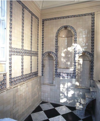
The last site was fed by a unique spring fed water tower and is an 18th century bath house lined by deft tiles called a Bagnio. Enclosed with the water house it was erected by Sir John Fellowes by 1721. It was described in 1724 by a John Macky as ‘curious waterworks in Fellowes garden’. Little is known of this plunge pool and no reference is made by Rattue and its first mention is only in 1839. The building pumped water from a spring nearby into a lead tank in the tower which then fed the bath. The original engine was replaced many years ago and only partial remains of mid-19th century water wheel survive in the wheel pit which can be seen. The bath itself is sunk below a marble floor to a depth of 1.37m and is lined with plain tiles, it has a marble floor and is reached by marble steps. under which are hidden lead inflow and outflow pipes It measures an area of 3.28m by 2.58. How it was heated is unclear as no hot water system survives however it may have simply functioned as a cold bath. Now water is found in the bath and has not for some time it would appear. Its secrets and stories are yet to be discovered in a suburb full of fascinating water history.
The healing springs of Hampstead
In celebration of the stirling work done by the London Springs, wells and water ways Facebook group and the Fellowship of the Springs I’d thought I would explore Hampstead. Extracted and revised from Holy Wells and Healing springs of Middlesex
In the Georgian period Hampstead was one of the playgrounds of a growing London Its clean air and open spaces was a major draw for the London society and a major addition was its waters, although compared to others their life was short.
Hampstead Wells a chalybeate water compared to Tunbridge Wells. Its water was bottled and sent to an Apothecary at the Eagle and Child in Fleet Street, although as Stanley Foord (1910) in his work Springs, Streams, and Spas of London notes the expense and difficulty of transport meant that this attempt of exploiting the spring was not very successful. The water was extracted from the head spring or pond, called Bath Pond. This was a rectangular piece of water 40 feet wide and 20 feet deep, but filled in the 1880s.
Despite the lack of success, in 1701 John Duffield erected buildings to exploit the mineral spring, which were later on the east side of Wells Walk. Finally an Assembly Room and the Pump room were established on Well Walk. Springs, Streams, and Spas of London notes that:
“The Assembly or Ball Room, built by Duffield, was of large dimensions, measuring 36 feet by 90 feet, of which a length of 30 feet seems to have been divided by a partition from the other, and known as the Pump Room; the two rooms being thus under one roof, and situated near where the entrance to Gainsborough Gardens now is.”
Furthermore, the Green Man tavern (renamed Wells tavern in 1849-50), a Chapel called Sion Chapel and gardens and bowling green were established. On the site of the Pump Room is a new red-brick house called Wellside, built in 1892, according was established. A number of medical experts gave evidence towards the springs’ efficacy. A Dr. Gibbons states that it was ‘not inferior to any of our chalybeate springs, and coming very near to Pyrmont in quality’ and he himself took the waters until his death in 1725. Dr. Soame a noted 18th century physician published a book ‘Hampstead Wells, or Directions for drinking the Waters’, calling the spring “the Inexhaustible Fountain of Health’ yet the wells were in decline. Finally, in 1802, an analysis of the water was made by Royal college of Surgeons member, John Bliss who wrote in Medical Review and Magazine (Vol. VI.) that the water:
“have been found very beneficial in chronic diseases, &c., and where there is general debility of the system.”
In 1804 Thomas Goodwin, a local surgeon discovered another medicinal spring, called New Spa at the south-east extremity of the Heath, near Pond Street describing his findings in ‘An Account of the Neutral Saline Waters recently discovered at Hampstead’. Stating the water had sulphate of magnesia, that the waters were like that of Cheltenham’s saline spa. Its exact location according to Foord (1910) is unclear but he believes it is where Hampstead Heath Train Station now stands, although Mr. Goodwin marks it farther north.


The Long Room, 90 feet by 36 feet wide, with 30 feet used as a pump-room, was converted in 1725 into a chapel being called Well Walk Chapel and being used until 1861-62, when the Rifle Volunteers (3rd Middlesex), hired the chapel for a drill hall, and during the refit basins and pipes were found in the north end being where visitors to the Spa, were supplied with water. Analyses of the Hampstead chalybeate water have been made over the years, Soame in 1734 describes it as having a taste of vitriol of iron and Monro (1770) a Treatise on Mineral Spring states it is a transient Chalybeate lighter than New River water that had been boiled, but heavier than distilled water. By 1870, water from Well Walks spring and that from the fountain on Well mark, on the west side near no 17, noted it was a chalybeate spring mixed with surface water, possibly because the original source was diverted. In around 1885 the public basin on the east side of Well Walk was removed and a new stone drinking fountain was placed by the Wells Charity on the opposite side. In Foord’s time the water could still be drunk, although a sign was on the structure warning against this. Although C.A. White (1910) Sweet Hampstead and its associations noted that in the 1850s:
“it was quite common for working men from Camden and Kentish Towns, and places much farther off, to make a Sunday morning’s pilgrimage to Hampstead to drink the water, and carry home bottles of it as a specific for hepatic complaints and as a tonic and eye-wash.”
Sadly the well is now dry and despite an attempt to connect to the mains no water is accessible at the well.


The only surviving chalybeate spring in Hampstead is Goddison’s Fountain found can be found by following the path downhill from the east side of Kenwood House outside of the house grounds. The fountain is found on the left just as a pond appears on the right. The present structure was built in 1929 as a monument to Henry Goddison who was one of the main campaigners involved in saving the Heath and Kenwood estate for the public. There is no evidence that the spring was exploited before this but it was likely. It certainly is now and it is common to see walkers slake their first there and others collect water in demijohns.


At Kenwood House there is a brick and domed Bath House, it is easily found at the steps leading to the café. This was erected in the early 18th Century, it is believed by the Mansfield family, when they bought the house in 1754. Records show that they ordered marble fittings, purple tiles and oyster shells to decorate the niches. They probably bathed weekly or monthly. A sign on the inside of the door reads:
“The Cold Bath – The Cold Bath is fed by a natural spring of chalybeate water. It was built in the early 18th century when cold plunge bathing became fashionable and was considered a healthy pursuit. The Bath was neglected for many years, and had filed up with silt by the 1980s, when excavation work started. The marble linings had been stripped out and the sides were caving in. Enough evidence was found in excavation to reconstruct the marble lined bath. The dome was restored, and the walls re-plastered. The painted finish is speculative, based on the decorative schemes popular around 1800.”
It is designed as a plunge pool, being ovoid in shape with steps descending into the water at either side of the doorway. It resembles the structure, albeit smaller, of Birley Spa, near Sheffield (see Holy Wells and Healing springs of Derbyshire). The interior walls follow the ovoid shape and have three narrow niches set into the plaster work presumable arranged for statues. The bath water is supplied by a very copious chalybeate spring and is currently very full, but where this drains to is unclear. The site was derelict restored in the 1990s with the bath being full of debris.
Finally it is worth noting that there is a modern house called ‘Lady Well’ it may record a lost holy well but there is no evidence by a modern house name.
The old baths of London – The Roman Bath of the Strand
Situated beneath 5 Strand Lane is one of the city’s most enigmatic and perhaps little known relic, the so-called Roman Baths. Laying four feet six inches (1.4m) below the modern street level, the bath measures about 15 foot (4.72m) by 6 feet (1.91m), with a depth of just over four feet (1.37 m) deep. Its lining is built from bricks measuring 9 inches (22.9 cm) by 3 inches (7.6 cm) and is 1.75 inches (4.4 cm) thick.
John Pinkerton (1784) is the first author to describe the site, called it a:
“fine antique bath’ in the cellar of a house in Norfolk Street in the Strand formerly belonging to the Earl of Arundel whose house and vast gardens were adjacent”
The next notice was when MP William Weddell, a well-known antiquarian died of a sudden chill when bathing there in April 1792. Even Dickens (1849) used the bath as a location in David Copperfield having the titular character having cold plunge within and describes it as ‘at the bottom of one of the streets out of the Strand.’ A sign on the baths in the eighteenth century, put up by its then owner read:
“the celebrated Cold Plunging Bath (built by the Earl of Essex in the reign of Queen Elizabeth, 1588) is open all the year round. It is known to be the most pure and healthy bath in London ensuring every comfort and convenience to those availing themselves of this luxury. This bath, which is strongly recommended by the Medical Profession, is essentially supplied from the Spring, and discharges at the rate of ten tons per diem. Consequently, every bather has the advantage of a continual change of water. The old Roman spring water bath, nearly two thousand years old, can be viewed.”

Roman or more recent?
Despite this claim the actual origins of the origins of the bath are unclear. Although Roman London lay 1 mile (1.6 km) to the east and all the remains appear to suggest a Tudor origin at the earliest. They may have indeed been built for Arundel House, which was built by the Earl of Essex as a water cistern. When this house was lost in the 16th century, the area was built over by a row of houses and it was only rediscovered after a fire in 1774. A man called James Smith appeared to be responsible in converting the derelict cistern into a cold bath when he moved into No 33 Surrey Street in the mid 1770s. He soon started to advertise it as:
“the cold bath at No. 33, Surry-street, in the Strand … for the Reception of Ladies and Gentlemen, supplied with Water from a Spring, which continually runs through it.”
Two years later he constructed a second bath which was lined with marble. This the Essex Bath survives robbed of its cladding in the basement on the Norfolk Hotel but currently due to the building being empty is inaccessible.

A survey of the brickwork by Dr. Kevin Hayward of Pre-Construct Archaeology in May 2011 revealed that brickwork and tiles to date from 1450 to 1700. Further chemical analysis by Dr Stuart Black of University of Reading suggested a date between 1550 and 1650. Although, the date would support the cistern origin for Arundel House, Trapp (2010) believes that it may have been associated with the grotto fountain, said to represent Mount Parnassus or Helicon, in the privy garden of adjoining Somerset House. The area where it stood was being redeveloped in the 18th century. Trapp (2010) notes that Treasury Warrant book for April 1710 records a petition from Thomas Vernon, the then owner of this land nearby which records:
“for the grant of a little old shed in Strand Lane…being 14 feet square, formerly a water house to a grotto in Somerset House but now in ruinous condition and like to fall into the petitioner’s land.”
This is clearly the Roman Bath for its dimensions are identical and Vernon’s property Surrey Street property would have abutted the site. Interestingly a record of 1724 which records ‘Old Waterhouse’ (a decayed building of no use)’ suggests it was still standing and when it was demolished and became the bath today is unclear.

The source of water
It may seem so surprising in an area where so many wells have been capped, filled in and culverted into sewers, the water supply has been relatively constant bar when in the 1940s it was blocked with rubbish or during 1970s building work. However it has been unclear how where it comes from.in the mid 1800 it was bubbling from a hole in the floor but this was apparently patched over, then meaning by the early 1920s it entered by the north-east corner but since then it has been supplied via a settling tank at its east end.

It is probable that one of a number of lost holy wells fill it either St Clement’s Well or the Holy Well which gave Holywell street its name. Certainly the properties of the water being high in phosphate could suggest it was a medicinal spring
A remarkable survival
Despite not being as the 1838 advertising would say an ‘Old Roman Bath’ the bath’s survival is no more remarkable. In 1893, one of its users a New Oxford Street draper called Henry Glave bought the complex – he sold off the Essex bath and its building and focused on the older one refurbishing it by using the Essex Bath’s stone flooring, marble lining and wall tiles and creating changing-stalls and decorative sculpture. The family, the site being inherited by his daughters, ran the site until 1922 when it was offered for sale for £500. It was subsequently purchased by the Rector of St Clement Danes, the Reverend William Pennington Bickford. His ambition was for the bath to be restored to its Roman glory and be a major historical monument. He was supported by historian Edward Foord who wrote about its provenance. The plans never materialized and then when he died in 1941 it was bequeathed to St Clement Danes patron, Lord Exeter. Then through various complications it ended with it being taken over by the National Trust but controlled by Westminster Council who would organise the day to day maintenance. After some decorations it was opened once more to the public in June 1951.
On a recent Open London Day I was able to have a closer look again. The site is remarkable as being still full of water in a city with demands on water and a plus are the remarkable Dutch tiles. Of course no one is able to take a bath in it but it remains a curious relic of London’s cold bath system – the only one remaining of many in the city
